Flood Cell 5
Click the image above to view/download the full Flood Cell 5 map
INTRODUCTION
This cell of 556 hectares lies on the south side of the River Alde from the Anchorage at Iken downstream to the high ground directly opposite Aldeburgh Marshes.
The land-use of this flood cell is primarily semi-permanent wet grassland grazed by sheep and cattle with some areas in HLS. Around 15% of the cell is arable, mainly at the western end. Within this area is the Iken Decoy, an 18th century duck decoy, and is surround by mature alder and oak. Intertidal habitat in front of the defences is internationally designated and some of the land in the east of the flood cell has been managed for nature conservation. This land now contains habitat that supports a range of wetland birds, including a significant breeding population of avocets. The avocet is a qualifying feature of the adjacent Alde and Ore Estuary Special Protection Area (SPA) and the birds breeding within this flood cell are considered to be a part of the protected population.
…………………………………………………….
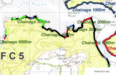
UPGRADE DESIGN PLAN
The map above and the upgrade design document below detail the work we need to do.
To Download the full plan, please click the link below